Share This

Showing posts with label Global Positioning System. Show all posts

Tuesday 1 May 2012

China successfully launches two more Beidou navigation satellites

China has moved a step closer to completing its own navigation and positioning satellite network with the launch of two more navigation satellites.

China plans to launch 35 navigation satellites

It brings the Beidou system, which became operational with coverage of China last December, to 13 satellites.

To have global coverage, the country eventually aims to have 35 satellites in orbit by 2020.

China hopes that Beidou will wean it off the US Global Positioning System.

Just like GPS, the Chinese system is designed to let users determine their positions to within a few meters.

Beidou, also known as Compass, has been developed for both military and civilian uses.

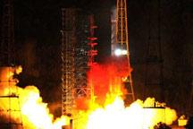
The two satellites went up on Monday morning from the Xichang Satellite Launch Centre in southwest Sichuan province.

They were carried on a Long March-3B rocket, according to the state-run Xinhua news agency.

"The two satellites will help improve the accuracy of the Beidou, or Compass system," Xichang Satellite Launch Centre said in a statement carried by the agency.

GPS
  • Sat-nav systems determine a position by measuring the distances to a number of known locations - the spacecraft constellation in orbit
  • In practice, a sat-nav receiver will capture atomic-clock time signals sent from the satellites and convert them into the respective distances
  • A sat-nav device will use the data sent from at least four satellites to get the very best estimate of its position - whether on the ground or in the sky
  • The whole system is monitored from the ground to ensure satellite clocks do not drift and give out timings that might mislead the user
Now partially operational, Beidou makes China only the third country in the world, after the US and Russia, to have its own navigation system.

Russia's Glonass satellite network has 31 satellites in orbit, but only 24 of them are operational. Four more are in reserve, one undergoing trials, and two under maintenance.

According to the Russian Space Agency, Roscosmos, Russia plans to spend $694m (£427m) on its Glonass system this year.

At a recent annual Satellite Navigation Forum in Moscow, Russia's deputy prime minister Vladislav Surkov said that more than 300 billion roubles (£6bn, $10.2bn) have been budgeted to further develop Glonass and bring 30 satellites into operation by 2020.

Europe has also been building a navigation system, called Galileo, which has two satellites in orbit, launched in October last year. The next two are scheduled to follow later this year.

The space project of the European Commission, the EU's executive arm, plans to have all 26 Galileo satellites in orbit by the end of 2015. - BBC Newscribe : get free news in real time


China has successfully launched a pair of navigation satellites. The launch took place on Sunday Morning from Xichang Satellite Launch Center and marks the first time the Long March 3B launch vehicle has been used for this kind of mission.

The Compass Navigation Satellite System is China’s second-generation satellite navigation system, capable of providing continuous, real-time passive 3D geo-spatial positioning and speed measurement.

The Long March-3B rocket carrying two satellites blasts off from the launch pad at the
Xichang Satellite Launch Center in Xichang,southwest China's Sichuan Province,on April
30,2012.China successfully launched two satellites into space Monday morning,the 12th
and 13th of its indigenous global navigation and positioning network known as Beidou,
or Compass system,the launch center said.(Xinhua/Tao Ming)

Related posts:
China implements Beidou navigation satellite system ...
Chinese Rocket Launches New Navigation Satellite

Wednesday 28 December 2011

China implements Beidou navigation satellite system; World's top 4 navigation systems: GPS, GLONASS & Galileo


China implements Beidou navigation satellite system

Watch Video

Play Video


China is implementing the second generation of its navigational satellite system, known as Beidou. The State Council Information Office held a press conference Tuesday to announce its Initial Operational Capability.

Ran Chengqi, the Director of the China Satellite Navigation Office introduced China’s global navigation satellite system. Beidou is independently established and operated by China. It can provide accurate, reliable all-time, all-weather positioning, navigation and timing services.


The State Council Information Office held a press conference Tuesday to announce its
Initial Operational Capability.


Ran says there are three steps in Beidou’s development. Ran Chengqi, director of China Navigation Satellite Office, said, "The first step was achieved in 2000 when the Beidou satellite demonstration system was established. It made China the third in the world to possess its own independent navigation satellite system. The second step is that the system will be able to provide services to the Asia-Pacific region by 2012. The third step is that by the year 2020, the system will be completed with global coverage."

China is implementing the second generation of its navigational satellite system,
known as Beidou.
So far, ten satellites have been launched, forming the basic system. Ran Chengqi announced that from now on, Beidou will officially provide Initial Operational Service to China and its surrounding areas. Services include continuous positioning, navigation and timing.

Beidou is one of the four satellite navigation systems in the world. The other three are America’s GPS. Russia’s GLONASS, and Europe’s Galileo.


World's top 4 navigation systems

Watch Video

Play Video


Besides China's Beidou, there are three similar services around the world: the GPS of the US, the Russian Glonass and the EU’s Galileo.

The Global Positioning System, or GPS, was developed by the US in the 1970s and completed in 1994. It is the most widely used navigation system now. GPS provides location and time information in any weather, anywhere on or near Earth. GPS was originally run with 24 satellites, and four backup satellites have since been added. The system provides two types of signals, one for military use and the other, civil.

Russia’s GLONASS - or Global Navigation Satellite System developed since 1976, had achieved full coverage of Russian territory by 2010. Now the total number of satellites in orbit is 28, among them, 23 are in operation, 3 are under maintenance, and 2 are being tested. Though its precision is a little less than GPS, it is a strong performer with few operational interruption.

The European Union’s satellite navigation system is known as Galileo. It is the first navigation system to focus on civilian use, and aims to provide high-precision positioning services for European nations. Galileo is formed of 32 satellites and two ground operations centres. Compared with GPS, its precision level is ten times higher.

China has now developed the Beidou Satellite Navigation System, which can operate unmanned. It includes five static and 30 non-static satellites, and its locating precision reaches ten metres. It not only provides navigation, location and timing services, but also a communication service. Compared with the other systems, Beidou has a much stronger location performance.

As the Beidou Satellite Navigation System is further developed, China is now applying the system to more areas, such as the transportation of dangerous items, postal services and even car rental.

Navigation systems: GPS, GLONASS & Galileo

Watch Video

Play Video


Besides Beidou, there are three other satellite navigation systems in the world. They are the GPS of the United States, GLONASS of Russia, and GALILEO of the European Union.

GPS, or the Global Positioning System, was developed by the US in 1970s. It provides location and time information in all weather, anywhere on or near the Earth.

GPS was originally run with 24 satellites, and four backup satellites have been added. GPS provides two types of signals, one for military use and the other civil.

GLONASS, the Global Navigation Satellite System, is a radio-based satellite navigation system developed by Russia starting from 1976. By 2010, GLONASS had achieved 100 percent coverage of Russia's territory. In October 2011, the full orbital constellation of 24 satellites was restored, enabling full global coverage. It displays high-level performance in avoiding interruptions.

Galileo is a satellite navigation system developed by the Europeans. It is the first civil use oriented navigation system and aims to provide a high-precision positioning service for European nations. Galileo is formed of 32 satellites and two ground operations centers. Compared with GPS, its precision level is ten times higher.